| Woodstock- Strasburg (Route 66)
292 Just before crossing under route 601, outcrop flanks the road on right and left. Tracing the bedding planes makes it easy to see that the tilt, or dip, of the strata is about 60 degrees to the northeast. This means that by driving north, you are traveling upsection from older to younger rocks. Changing rock features in the outcrop, therefore, parallel changes in the environment during the time of deposition. This unit of bedded dolomite, known as the Beekmantown Formation, was deposited about 500mya, in a divergant continental margin (DCM). A close up photograph of the beds shows algal laminations,indicating that the rock was deposited in a tidal environment. These algal laminations are sparse at the base of the outcrop, and are often interupted by small trough cross-beds and mud pebbles.
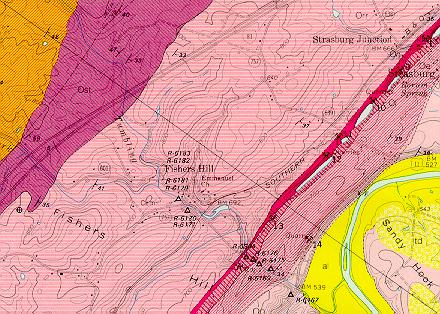
298 Near Strasburg, Route 81 carves through several hundred feet of outcrop on both the east and west roadsides. These rocks bely the transition between the Lincolnshire and Edinburg limestones (@460mya). These carbonates are an important Virginia mining resource. An examination of the map below shows that during the time of printing, at least five active quarry sites traced the northeast strike of the beds near Strasburg. (These sites are designated with crossed hammers.) To the west (left), just before the underpass is a view of one of these quarries. Click on the photo for a close up of the belts used to transport and crush the stone. It is fortuitous that the rock in this area is exposed, because it carries some intriguing finds. An abrupt color change from light to dark gray occurs on the west (left) exposure, showing the contact between Lincolnshire and Edinburg Formations. Scattered in the grass below the lower exposure are giant black eggs. These are chert nodules, resistant plugs of rock that form within the less resistant limestones of the Lincolnshire. Erosion destroys the surrounding limestone, freeing the chert which falls heavily to the ditches below. Geologic Map and Cross Section of Strasburg, VA Area1
 A' A' ROUTE 66E ->> |